Canyonlands 2026: Island in the Sky vs the Needles
Pick the right district first—Island in the Sky vs the Needles, White Rim logistics, 2026 fees, and trails worth your time in Utah’s biggest overlooked park.
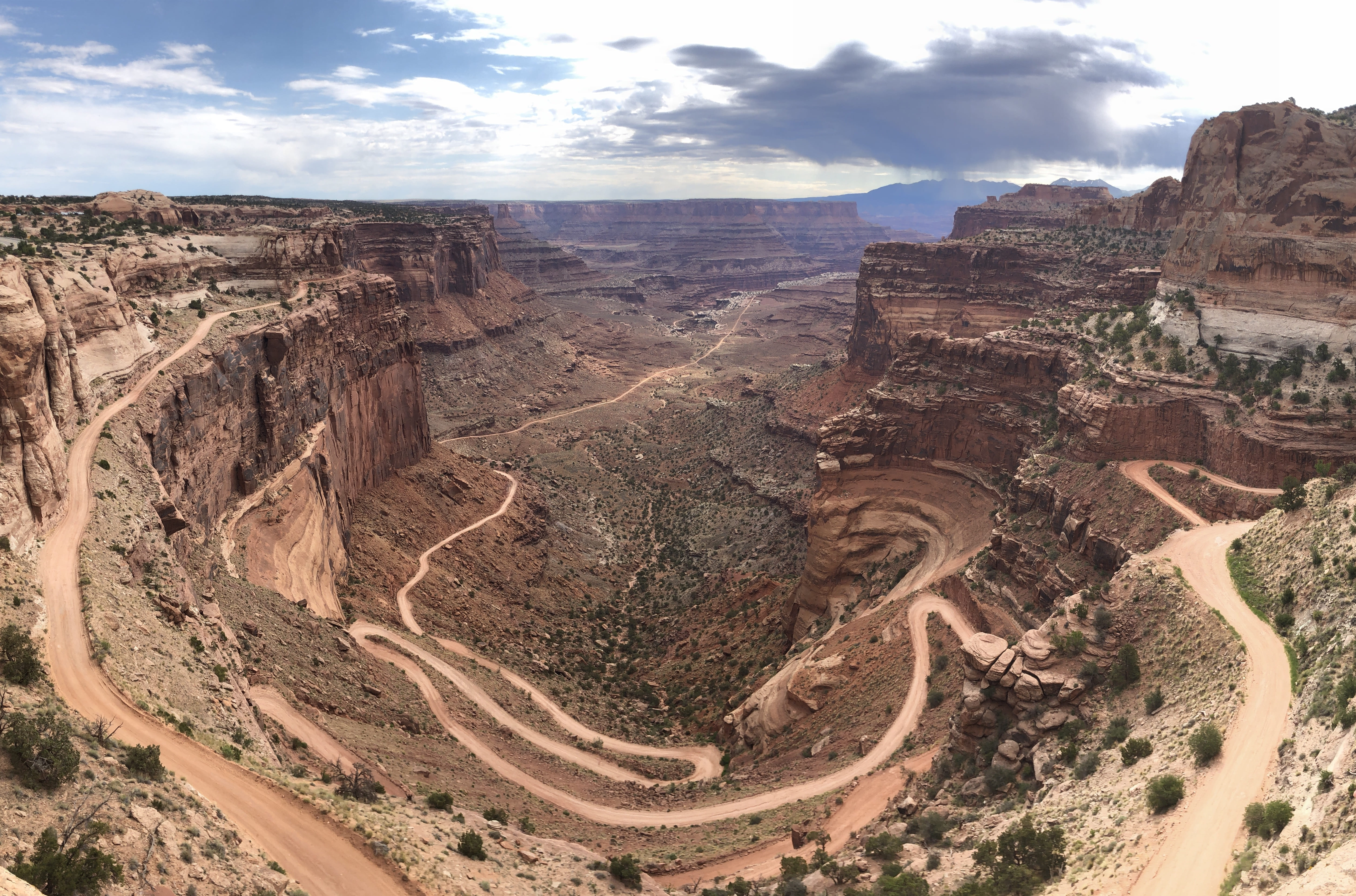
Table of Contents
The most common mistake people make with a Canyonlands National Park guide is treating it like a scaled-up version of Arches. It's not. Canyonlands is 527 square miles — bigger than Los Angeles — split into three completely separate districts with no connecting roads between them. Understanding how this park actually works before you arrive will save you hours and make your trip dramatically better.
2026: What to Know Before You Go
If you're visiting the Needles District, there's a mandatory road detour in effect. Hwy 211, the normal access road, has been closed since flash flood damage and remains unrestored as of April 2026. To reach the Needles, take the detour from Monticello: turn west onto 200 South at the Monticello Visitor Center, follow Hart's Draw Rd approximately 18.5 miles, then turn left onto Hwy 211. Add meaningful extra time to your drive — and don't trust GPS apps that haven't updated for this reroute.
For Island in the Sky visitors, the road situation is straightforward as of April 2026. The Scenic Drive, Shafer Trail, and Potash Road are all open to standard vehicles. White Rim Road, Taylor Canyon Road, and Lathrop Road are open but require high-clearance 4WD — don't attempt them in a rental sedan, regardless of what Google Maps suggests.
📋 Park hours, entrance fees, live alerts, campground bookings, and trail maps are all on the TrailVerse park page — this guide covers the strategy.
The Three Districts (And Why This Matters)
This is the single most important thing to understand about Canyonlands: the three districts have zero connecting roads. Traveling from Island in the Sky to the Needles takes 2+ hours each way, even though they're in the same park. If you drive to Island in the Sky and decide mid-afternoon that you also want to see the Needles, you're committing to a 4+ hour round trip with no time left to actually hike. Pick one district per visit.
Island in the Sky is the mesa-top plateau 32 miles northeast of Moab and the district most visitors see. A 34-mile scenic drive connects the major overlooks — Mesa Arch, Grand View Point, Upheaval Dome — all accessible from paved roads. It's the right choice for a first visit, a single-day trip, or anyone who wants dramatic canyon panoramas without technical challenges.
The Needles sits in the southern part of the park and gets far less traffic than Island in the Sky. The landscape shifts completely — towering red and white banded spires, archaeological sites, and genuine backcountry hiking. Access is from Hwy 211 off US-191 (see the 2026 detour above). Budget 2+ hours of driving from Moab plus the detour time, and treat this as a separate day or a separate trip entirely.
The Maze is in a category of its own — one of the most remote wilderness areas in the continental United States. You need a high-clearance 4WD vehicle just to get there, a two-day minimum to reach any destination inside, and full expedition planning — no cell service, no services of any kind, technical navigation, and genuine risk if something goes wrong. Only a few thousand experienced hikers make it each year. Don't casually add it to an itinerary.
One genuinely undervisited addition: Dead Horse Point State Park sits 20 minutes from the Island in the Sky visitor center. It offers panoramic views from 2,000 feet directly above the Colorado River's horseshoe bend. It holds its own IDA dark sky certification and gets a fraction of the Canyonlands crowds. Separate admission, but easily combines with an Island in the Sky day.
Canyonlands vs Arches
Arches National Park and Canyonlands are 26 miles apart, and people constantly ask which one to visit. The honest answer: they're completely different experiences, and comparing them is like comparing a museum to a wilderness preserve.
Arches is about the formations — iconic arches that frame the sky and landscape, short, accessible trails, and intimate photographic compositions. You can see the highlights in a half day. The crowds are real: Arches drew 1.48 million visitors in 2023, and the entry reservation system that ran through 2025 reflected that pressure.
Canyonlands is about scale, solitude, and wilderness. 800,322 visitors in 2023 — roughly half of Arches — spread across 527 square miles. The vistas are sweeping rather than intimate. The hikes are longer, the terrain rougher, the crowds thinner. If you want to stand at a rim and feel genuinely small, Canyonlands is the park.
If you have one day and you're new to southern Utah, go to Arches first. Want wilderness, long hikes, solitude, or serious dark sky photography? Canyonlands. Best answer if you have time: do both. They're different enough that one doesn't replace the other, and 30 minutes of driving connects them.
When to Go
Spring (March–May) and fall (September–October) are the best windows, with May and October being the peaks for a reason — the temperatures are ideal for hiking and the light is extraordinary. The tradeoff is that everyone else knows this too, so Island in the Sky will have company.
Summer (June–August) brings temperatures that regularly hit 95–110°F on the canyon floor. It's genuinely dangerous hiking weather if you're not prepared, and mid-day hikes are a bad idea regardless of preparation. That said, summer is peak Milky Way season, which makes it worth considering for astrophotographers who can work at night and rest during the heat.
Winter (November–February) is Canyonlands at its most solitary. Temperatures drop to 20–50°F, some roads close with ice, and the White Rim Road crowd essentially vanishes. If you have the gear and the layering system, it's a remarkable time to visit.
Season | Dates | Temps | Crowds | Best For | Watch Out For |
|---|---|---|---|---|---|
Spring | Mar–May | 50–80°F | Medium (peak = May) | Best hiking weather, wildflowers, Milky Way starts | Afternoon thunderstorms, May crowds |
Summer | Jun–Aug | 85–110°F | Medium-Low | Dark sky photography (otherwise brutal) | Flash floods, extreme heat — avoid mid-day |
Fall | Sep–Oct | 55–80°F | Medium (peak = Oct) | Best all-around conditions | October busier than expected |
Winter | Nov–Feb | 20–50°F | Very Low | White Rim Road, solitude | Ice on trails, cold nights, some road closures |
The Trails and Overlooks Worth Knowing
These aren't comprehensive trail listings — they're the ones worth having an opinion about before you arrive.
Mesa Arch (0.5 mile RT, easy) is the most photographed spot in the park, and the reason is obvious the first time you see it: the arch frames the La Sal Mountains and a sheer canyon drop simultaneously. At sunrise, photographers line up for tripod space — arrive before dawn or accept company. One non-negotiable safety note: the arch sits directly at the canyon rim, and there have been fatalities from people standing too close to the edge. Stay back. This applies to you, your kids, and your tripod at night.
Grand View Point (2 miles RT, easy) is the southernmost tip of the Island in the Sky mesa. The 360° panorama from here is what the park's scale actually looks like — canyon systems in every direction, with nothing but more canyon to the south. Sunset hits the walls with warm orange light that makes this the best end-of-day stop in the park.
Upheaval Dome (1–2 miles RT to overlooks) is a two-mile-wide circular feature that scientists still can't fully agree on — it's either a meteor impact crater or a collapsed salt dome, and both camps have credible evidence. Two overlooks are accessible from the parking area. The first gives you the overview; the second, accessed by a brief scramble, gives you the better composition.
Syncline Loop (8.3 miles, strenuous) is where to go if you're an experienced hiker looking for the park's most demanding day. It's also where most rescues in the park happen. The 1,300-foot elevation change, boulder fields, and steep grades become genuinely dangerous when wet. If you're not confident in your desert hiking experience, this is one to leave for a future trip.
White Rim Road (100 miles, 4WD) is one of the great backcountry drives in the American West. It loops below the Island in the Sky mesa along the canyon rim, taking 3–4 days to complete by vehicle. A permit is required, planning starts months out for popular dates, and you'll need a high-clearance 4WD that you're comfortable with in remote terrain. For the right traveler, it's worth organizing an entire trip around.
What Most People Get Wrong
The districts are not connected. You can't drive from Island in the Sky to the Needles without leaving the park and spending 2+ hours on public roads each way. This isn't a minor detail — it completely changes how you plan your time. One district per day, or better, one district per trip.
Canyonlands is not a smaller, less crowded Arches. They're structurally different parks with different experiences. Arches gives you geological formations and short accessible trails. Canyonlands gives you wilderness scale and sweeping canyon vistas. Choosing between them based on crowds alone means you'll miss what makes each one worth visiting.
The Maze is a full expedition, not a day hike. No cell service, no services, technical 4WD navigation, and a two-day minimum to reach any destination. It's one of the most remote areas in the lower 48. Treat it like a multi-day backcountry expedition or don't go.
False Kiva is officially closed. The alcove containing the ancient stone circle was closed after repeated vandalism. You can hike the unmarked trail and view it from behind a rope barrier, but the classic interior shot — the one you've seen in every Canyonlands astrophotography gallery — is no longer legally accessible. Don't cross the barrier. It protects a roughly 1,000-year-old archaeological site.
Syncline Loop sends people to get rescued. Park data shows this trail has the most rescues — boulder fields and steep grades don't forgive overconfidence. If you're not confident in desert hiking, save it for another trip.
The Night Sky (Brief)
Canyonlands holds a Gold-Tier International Dark Sky Park certification, awarded in August 2015. The park rates at Bortle 2–3 in accessible areas near Island in the Sky due to Moab's light dome to the east, with the Needles and the Maze interior touching true Bortle 1. Either way, you're looking at Milky Way structure visible to the naked eye, zodiacal light in season, and the kind of sky most people have never seen.
The signature shot is Mesa Arch with the Milky Way rising through the opening in spring — a composition that no other dark sky location in the country replicates. In April and May, the galactic core rises through the arch around 1–3am.
🌌 The Canyonlands Astrophotography Guide — Bortle class, Nikon Z6II settings, Milky Way calendar, and best shooting locations.
Getting There & Base Camp
Island in the Sky visitors base in Moab, 32 miles northeast of the district. There are no services inside the park — no gas, no food, no water. Fill your tank, load your cooler, and carry your water before you enter. Moab is a well-developed gateway town with plenty of accommodation options.
Needles District visitors use Monticello as their gateway. With the 2026 Hart's Draw detour in effect, account for additional driving time from any direction. Like Island in the Sky, the Needles has no services inside the park.
The Maze requires full expedition logistics — treat it like a self-supported backcountry trip, because that's exactly what it is.
Gear for This Park
Platypus Platy 2L × 2 — 4L per person per day, minimum. There are no water sources anywhere inside the park. This isn't a guideline that adjusts based on how fit you are or how short your hike is. The Platy collapses flat when empty so you can carry two without bulk, and at 1.3 oz each they add almost nothing to your pack weight. Fill both at your Moab lodging and carry them in — dehydration in the desert hits faster than you expect, and the nearest help is a long way away.
Gaia GPS — download offline maps before you leave Moab. Cell service drops out in the Needles and is nonexistent in the Maze. Even the 0.5-mile Mesa Arch trail starts in pre-dawn darkness for the sunrise shot, and backcountry trailheads in the Needles are genuinely hard to find without reliable offline navigation.
Columbia Silver Ridge Utility Lite — you're hiking at 5,500–6,000 feet elevation in the desert, where UV intensity is brutal and there's no shade at Mesa Arch, Grand View Point, or anywhere on Island in the Sky's overlooks. The Silver Ridge's Omni-Shade UPF 50 blocks the full spectrum of UVA/UVB rays, the vented back panel keeps air moving when canyon temps spike midday, and the roll-up sleeves let you adjust as temps swing between cool mornings and hot afternoons. Pair it with a wide-brim hat — sunscreen alone isn't enough at this altitude.
Power bank — no charging options inside the park, and desert heat or winter cold drains phone batteries faster than you expect. A 10,000mAh power bank sized for at least two full phone charges is worth carrying. Essential if you're using Gaia GPS as your primary navigation.
High-clearance 4WD is required for White Rim Road, all Maze access routes, and most serious Needles backcountry. If your rental car is a standard sedan, you're limited to the paved Island in the Sky scenic drive and trailhead pullouts — still excellent, but know your limit before you start.
Frequently Asked Questions
Canyonlands vs Arches — which should I visit?
They're 26 miles apart and entirely different experiences, so ideally both. Arches centers on the arch formations — short trails, intimate photography, accessible highlights. Canyonlands is about scale and wilderness — sweeping canyon vistas, long hikes, solitude, dark sky photography. First-time Utah visitor with one day? Arches. Looking for wilderness, fewer crowds, and serious hiking? Canyonlands. Have two days and a car? Do both.
How long do I need at Canyonlands?
One day covers Island in the Sky's major overlooks — Mesa Arch, Upheaval Dome, Grand View Point — with time for a moderate hike. Two days lets you add the Needles as a separate district (remember: 2+ hours of driving between them). The White Rim Road takes 3–4 days on its own and is worth planning an entire trip around. The Maze is a minimum two-day expedition.
Is the Maze worth visiting?
For the right traveler — yes, absolutely. For most visitors — no. The Maze requires high-clearance 4WD, full self-sufficiency, technical navigation skills, and a multi-day commitment. There's no cell service, no services, and no rescue infrastructure. If that sounds like your kind of adventure, it's one of the most remote and dramatic wilderness experiences in the continental US. If you're not sure, start with Island in the Sky and the Needles first.
What's the best time to visit Canyonlands?
May and October are the sweet spots — temperatures in the 55–80°F range, good light, and the best overall hiking conditions. Spring also brings the start of Milky Way season if you want to combine hiking with night sky photography. Summer is dangerous for daytime hiking above 100°F but excellent for dark sky work. Winter offers remarkable solitude if you're prepared for cold.
Keep reading
More on this topic from TrailVerse