Death Valley 2026: When It’s Actually Safe to Visit
Summer heat can be dangerous—spring superbloom and winter light are the sweet spots. 2026 fees, safe trails, and how desert seasons change your plan.
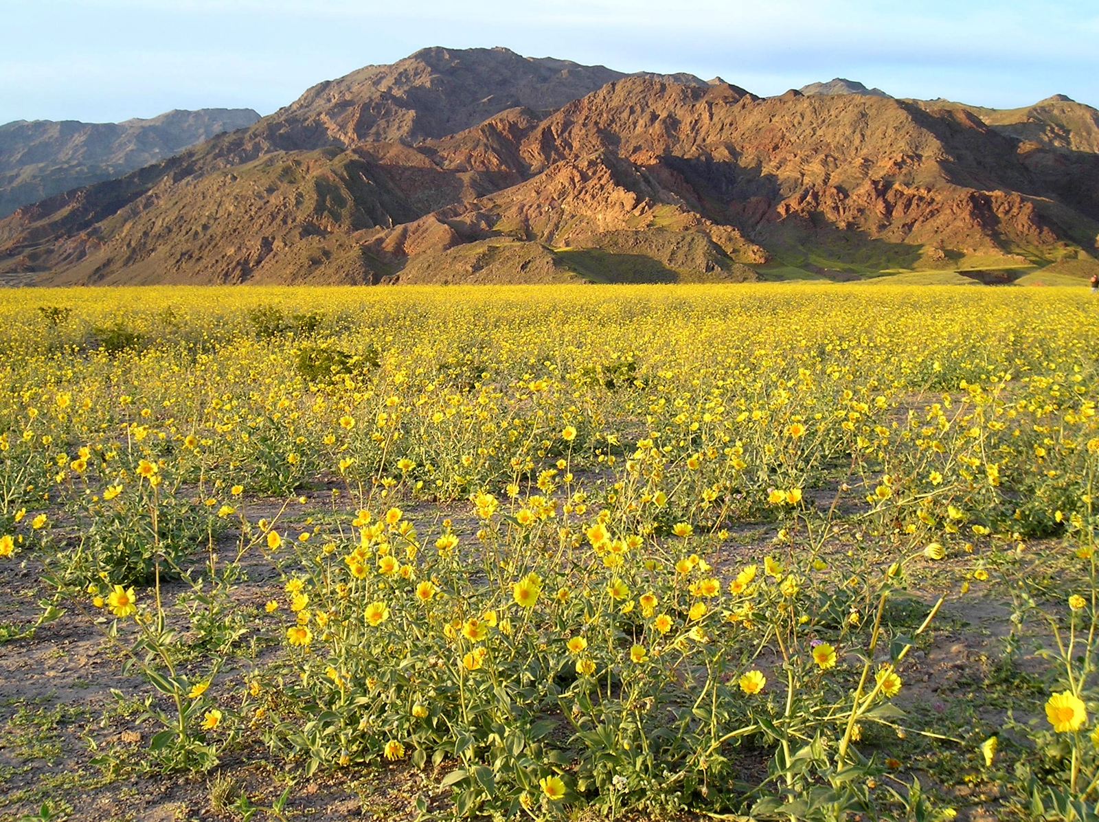
Table of Contents
This is the best year to visit Death Valley National Park in a decade. Record Fall 2025 rainfall triggered a wildflower superbloom — low-elevation blooms peaked in March, but higher-elevation blooms are active right now through April–June 2026. On top of that, Scotty's Castle has reopened for limited tours for the first time since 2015. Two rare events happening simultaneously, in the hottest, driest, lowest national park in the United States. Most people underestimate Death Valley. Here's what to know.
2026: Two Things That Changed
The Wildflower Superbloom
Fall 2025 brought 2.41 inches of rain to Death Valley — record-breaking for a desert that averages less than 2 inches per year. That water sat in the soil all winter, and now it's producing the best wildflower bloom in a decade. Lower-elevation blooms of Desert Gold, Phacelia, and Sand Verbena peaked in March along Badwater Road and the Ashford Mill area. The good news: higher-elevation blooms are still active and will continue through June 2026. Highway 190 and the surrounding hills are your best targets right now.
Superbloom years are genuinely rare. They require the right rainfall at the right time, and even then the timing shifts year to year. If you've been thinking about a Death Valley trip, 2026 is the year to stop thinking and start booking.
Scotty's Castle Reopens After 10 Years
In October 2015, a flash flood ripped through Grapevine Canyon, damaging Scotty's Castle — the park's most famous historic landmark — along with miles of roads and infrastructure. The castle closed that day. A 10-year, ~$90 million restoration followed.
In January 2026, limited ranger-guided 'Flood Recovery Tours' ran for the first time since the closure — 20 people per tour, $35 per person, select Sundays through March 29. They sold out immediately. Full reopening is still years away, but if you missed this season, join the waitlist at DVNHA.org for cancellations or 2027 dates
The castle's backstory is worth knowing. Walter Scott — "Death Valley Scotty" — was a conman who convinced wealthy Chicago businessman Albert Johnson that a secret gold mine in the desert was producing huge returns. The mine was fake. Johnson eventually came to investigate, discovered the fraud, and... fell in love with the desert anyway. He kept funding Scotty's lifestyle and eventually built a Spanish-style mansion in one of the most inhospitable places on earth. Scotty lived there rent-free for decades. Johnson called it a friendship. Historians call it one of the stranger stories in the American West.
📋 Park hours, entrance fees, live alerts, campground bookings, and trail maps are all on the TrailVerse park page — this guide covers the strategy.
Why Death Valley Is Worth It
Most national parks give you one superlative. Death Valley gives you several that don't belong together. Badwater Basin sits 282 feet below sea level — the lowest point in North America — while Telescope Peak rises to 11,049 feet just 15 miles away. The same park that holds the world's recorded high air temperature (134°F) also has the darkest skies of any national park in the contiguous United States.
The scale is unlike anything in the lower 48. At 3.4 million acres, it's the largest national park outside Alaska — bigger than Connecticut. Drive times across the park routinely exceed two hours. The salt flats, the sand dunes, the volcanic badlands, the painted hills — they're all here, and they don't look like anything else.
Death Valley is also the ancestral homeland of the Timbisha Shoshone people, who have lived in this valley for centuries and still maintain a permanent village here today. That context matters.
When to Go (The Timing Is Everything)
The heat in summer isn't an inconvenience — it's a survival issue. Death Valley regularly exceeds 120°F in June through August and has reached 134°F. People die here every year, often within a mile of their car, on what looked like a short walk in mild temperatures. Summer visits are for experienced desert travelers who understand what they're doing, stay on paved roads, and never get out of the car during daylight hours.
Here's the honest seasonal breakdown:
Season | Dates | Temps | Crowd | Best For | Watch Out For |
|---|---|---|---|---|---|
Spring | Mar–May | 70–100°F | High | Wildflowers, hiking, photography | Crowds peak March–April; wildflower timing varies |
Summer | Jun–Aug | 110–120°F+ | Very Low | Dark sky photography only | Fatal heat, no hiking mid-day, extreme hydration required |
Fall | Sep–Oct | 85–105°F | Medium | Hiking returns, photography | Still hot in September; October is the sweet spot |
Winter | Nov–Feb | 50–70°F | Medium-High | All-day hiking, Scotty's tours, Dark Sky Festival | Cold nights, some roads close |
October is the most underrated month. Temperatures drop to a manageable 85–100°F, crowds thin out after the spring rush, and the light is extraordinary for photography. Winter is excellent for hiking all day without heat risk — temperatures hover 50–70°F in the valley — and it's when the annual Dark Sky Festival runs (typically February or March).
In 2026 specifically, spring wildflower season extends the appeal through June at higher elevations. That's unusual. Don't miss it.
The Trails Worth Knowing About
Death Valley has dozens of trails. Most of them aren't worth your limited time here. These five are worth your attention.
Mesquite Flat Sand Dunes is technically a walk, not a hike — there's no marked trail, just 100-foot dunes you explore on foot. What makes it worth doing is timing: the rippled sand at golden hour, with the Panamint Range in the background, is one of the most photogenic scenes in any national park. Get there before 8am or after 5pm in April and May. Midday on these dunes, even in spring, is punishing — no shade, no water, reflected heat from the sand.
Zabriskie Point is 0.2 miles of paved path to one of the great sunrise views on earth. The eroded badlands glow orange-gold in early morning light. Arrive 30 minutes before sunrise to get parking — this is not a tip, it's a requirement. The lot fills fast.
Golden Canyon earns its name. The 3-mile round-trip trail winds through canyon walls striped red, gold, and ochre, ending at a formation called Red Cathedral. Spring wildflowers appear in the lower section during good bloom years. This is the best short hike in the park for people who want to feel like they're actually inside the landscape, not looking at it from a viewpoint.
Telescope Peak is Death Valley's best-kept secret, and it's hiding in plain sight. Most people don't know this park has an 11,049-foot summit. The 14-mile round-trip trail starts at 8,133 feet and gains 3,000 feet to the top. Snow is possible through April, and the trail requires an ice axe from October through May. The views from the summit — Badwater Basin directly below you, the Sierra Nevada to the west — are unlike any other perspective in the park. It's the most underestimated trail here.
Artists Drive isn't a trail at all — it's a 9-mile one-way scenic loop that most visitors drive straight past. The volcanic hills here have been stained red, pink, green, and gold by mineral deposits, and around 5pm when the light hits them at Artists Palette, the colors are jaw-dropping. It's free, it takes about 20 minutes, and it's consistently one of the most surprising things people see in the park.
What Most People Get Wrong
The heat will kill you. Not metaphorically. People die in Death Valley every summer — usually on short, familiar-looking walks without enough water, in temperatures that feel manageable until they aren't. Even 105°F is fatal without shade, water, and respect for the conditions.
GPS doesn't work reliably in the backcountry. Death Valley has massive cellular dead zones. Download offline maps in the Gaia GPS app before you enter the park. This isn't optional.
The distances are deceptive. At 3.4 million acres, drive times across the park routinely exceed two hours. The thing you want to see that looks "close" on the map is often 45 minutes away on a dirt road.
Most people miss the night sky entirely. Death Valley is a Gold-Tier International Dark Sky Park with Bortle Class 1–2 skies — the darkest in the contiguous US. People leave after sunset without realizing what they're walking away from.
Scotty's Castle 2026 tours sold out within days of opening. Join the waitlist at DVNHA.org — 2027 dates haven't been announced yet, but this is the only way in.
The Night Sky (Brief)
Death Valley earned Gold-Tier certification from the International Dark Sky Association in 2013. The interior of the park reaches Bortle Class 1 — the darkest designation that exists. The Milky Way is bright enough here to cast faint, diffuse shadows on the desert floor. That's something most people will never experience anywhere else in the US.
The best months for Milky Way photography are April through July. If you're serious about it, plan your visit around a new moon date. For the full breakdown — shooting locations, Nikon Z6II settings, new moon calendar, and deep-sky objects — read the Death Valley Astrophotography Guide.
🌌 The Death Valley Astrophotography Guide — Bortle class, Nikon Z6II settings, Milky Way calendar, and best shooting locations — publishes April 16. Subscribe to get it in your inbox.
Getting There & Base Camp
Las Vegas is the most practical fly-in gateway — it's 2 hours east of Furnace Creek. Los Angeles is 4.5 hours to the southwest. Most people driving from LA take Highway 395 north through Lone Pine, or cut through Mojave and Highway 127. Both routes work.
Furnace Creek is the main hub inside the park — it has the visitor center, the main gas station, lodging, and the closest access to most of the major sights. Stovepipe Wells has the only other gas station in the park. Fill up your tank before entering the park, and again at every opportunity. Running out of gas in Death Valley is a genuine emergency.
For budget lodging, Beatty, Nevada (40 minutes east of Furnace Creek) has motels and is a reasonable base for exploring the eastern half of the park. Pahrump, Nevada is another option about 70 miles away.
Gear for This Park
Platypus Platy 2L — Death Valley has zero water at any trailhead. The Platy collapses flat when empty so you can carry two without bulk, and at 1.3 oz it adds almost nothing to your pack weight. Bring two — one in hand, one in the bag. Running short on water here isn't inconvenient, it's a medical emergency.
Columbia Silver Ridge Utility Lite — At Badwater Basin you're sitting 282 feet below sea level on reflective white salt, getting UV from above and below simultaneously. Sunscreen sweats off within the hour. The Silver Ridge is built specifically for this — Omni-Shade UPF 50 blocks the full spectrum of UVA and UVB rays, Omni-Wick pulls sweat off your skin and dries it fast, and the vented back panel keeps air moving when there's no shade for miles. Roll-up sleeves with snap holders let you adjust on the fly as temps swing between morning cool and midday brutal. Purpose-built for desert hiking, not repurposed from another sport.
KEEN Newport H2 — The right footwear for Mesquite Flat Dunes, Zabriskie Point, and Artists Drive. Closed-toe design protects against the sharp salt crust at Badwater Basin, the siped rubber sole grips wet canyon rock in Golden Canyon, and the quick-dry straps handle heat without baking your feet the way leather does. Don't wear open-toe sandals on any Death Valley trail — the terrain punishes exposed toes.
Gaia GPS — Cell service disappears the moment you leave the main corridor in Death Valley. Google Maps and Apple Maps are useless in the backcountry, and the park is 3.4 million acres with dirt roads that look identical on a standard map. Download the Death Valley topo maps offline at home before you leave cell coverage — the free version handles this. Non-negotiable if you're attempting Telescope Peak, driving to Racetrack Playa, or doing self-guided Fiery Furnace. Rangers pull people out of this park every season because they trusted their phone's default map app.
Merrell Moab 3 Mid Waterproof — Required for Telescope Peak. The 14-mile round-trip gains 3,000 feet on rocky terrain with snow possible through April, and a low-cut trail runner won't cut it. The Moab 3's Vibram TC5+ sole handles loose scree and wet rock, the waterproof membrane keeps feet dry through snow crossings, and the mid-cut ankle support matters on the descent when your legs are shot. The bestselling hiking boot in the world for a reason — out-of-the-box comfort, no break-in miles needed.
Frequently Asked Questions
When is the best time to visit Death Valley?
October through April is the safe window for most visitors. October offers the best balance of comfortable temperatures (85–100°F), manageable crowds, and excellent light for photography. Spring (March–May) is ideal for wildflowers. In 2026, the higher-elevation superbloom extends the spring window through June. Avoid June through August unless you're an experienced desert traveler.
How long should I spend in Death Valley?
Two to three days is the minimum for seeing the main areas — Badwater Basin, Zabriskie Point, Mesquite Flat Dunes, Artists Drive, and Golden Canyon. Add a day if you want to drive out to Racetrack Playa or attempt Telescope Peak. A night sky session requires staying at least one night, ideally planned around a new moon date.
Is it safe to visit Death Valley in summer?
It's genuinely dangerous. The park sees heat-related fatalities every summer, typically in June through August when temperatures regularly exceed 120°F. If you do visit in summer, stay on paved roads, avoid any outdoor activity between 10am and sunset, carry a minimum of 4 liters of water per person at all times, and never rely on GPS or cellular service working.
Will I see wildflowers in 2026?
Lower-elevation blooms (Desert Gold, Phacelia, Sand Verbena along Badwater Road and Ashford Mill) peaked in March 2026. As of April 2026, higher-elevation blooms along Highway 190 are still active and expected to continue through June. Superbloom years are rare — this is the best bloom in a decade, triggered by record Fall 2025 rainfall of 2.41 inches.
Keep reading
More on this topic from TrailVerse