Explore

Hiking

From short nature walks to multi-day backcountry routes, find parks and sites known for trails and hiking opportunities. The NPS directory lists hiking at 275 parks and sites nationwide. Compare destinations below, filter to national parks only, and open any park page for trails, alerts, campgrounds, and trip planning.

275 parks and sites (NPS)

From NPS.gov

Watch this short video that highlights some of the benefits of hiking.

View on NPS.gov

You might also like

Related stories and places from NPS.gov, same as the official app.

About Hiking

  • A woman takes a picture beside a lake.

    Phelps Lake Loop

    Grand Teton National Park

    This moderate loop hike provides access to Phelps Lake as well as views into Death Canyon and the southern end of the Teton Range. Start the trail from the Laurance S. Rockefeller Preserve and follow the trail as it loops Phelps Lake. Those looking to extend the hike can add the Aspen Ridge or Boulder Ridge trails on the way to and from the lake.

    View on NPS.gov
  • A group of hikers and their dog walk through a prairie with tall grass on either side of the trail.

    Hiking the Blackland Prairie Section of the Natchez Trace National Scenic Trail

    Natchez Trace Parkway

    In and around Tupelo, Mississippi, this six mile section is a popular hiking and equestrian corridor for visitors. Bicycles are prohibited on this trail. You can pick up a Natchez Trace National Scenic Trail brochure by visiting the Natchez Trace Parkway Visitor Center near the northern terminus trail head at Milepost 266 on the Natchez Trace Parkway. Check Parkway Visitor Center hours here This trailhead is open to both hikers and horseback riders. This is the only staging area for horseback riders on the Tupelo section of Scenic Trail. A 3.5-mile loop trail is available for horseback riders. Safety Information At the following road crossing; creek crossing at milepost 264.5 and US 178 (McCullough Blvd.) crossing at Milepost 262.5, you must walk up to the Parkway and follow the road’s shoulder. Also be extremely careful at the railroad track crossing north of Chickasaw Village. See Alerts & Conditions and Road Site and Status for additional information. Areas on the Trail Northern Terminus Trailhead (Milepost 266): This trailhead is located just across the Parkway from the Natchez Trace Parkway Visitor Center. Hikers can travel six miles along the outskirts of Tupelo (12 miles roundtrip). You can make the walk as long or as short as you would like on this out and back trail. This section of Scenic Trail is open to hikers only and requires walking on the Parkway for road and creek crossings. Old Town Overlook (Milepost 263.9): Hikers can continue north for 2 miles to reach the Parkway Visitor Center or continue south for 2 miles to reach the Chickasaw Village Site. This section of Scenic Trail is open to hikers only and requires walking on the Parkway for road and creek crossings. Chickasaw Village (Milepost 261.8): The Chickasaw Village Site provides hikers access to the Natchez Trace National Scenic Trail, as well as a one-half mile interpretive trail. The half mile trail identifies plants and their uses by American Indians, especially the Chickasaw. Visitors can continue north to the Old Town Overlook and Visitor Center or can make a loop by using the horse trail and hiking trail. This section of Scenic Trail requires walking on the Parkway for road and creek crossings. The trail on the south side of the prairie is closed due to storm damage. Directions From the Natchez Trace Parkway, exit onto Highway 6 at Milepost 260. Travel west on MS Highway 6 for ap…

    View on NPS.gov
  • Trail junction on the Yockanookany section. Brown sign with yellow letters alerts visitor to trail.

    Hiking the Yockanookany Section of the Natchez Trace National Scenic Trail

    Natchez Trace Parkway

    North of Jackson, Mississippi the Yockanookany section of the Natchez Trace National Scenic Trail is the longest of the five developed trail sections at 26 miles. Eight miles run alongside the Ross R. Barnett Reservoir, and the other sixteen miles go through dense forests, seasonal streams and open pastureland. There is a lot to see on this stretch of trail; many sites are accessible via short side trails (you may have to cross the parkway). The trail parallels the parkway roadbed; use caution at all times, especially at bridge crossings, where you must walk along the Parkway road. Camping is not permitted along this section of trail. All camping must take place in designated campgrounds unless you received a special use permit in advance. See Camping on the Natchez Trace Parkway for additional information. See Maps for additional information. See Alerts & Conditions and Road and Site Status for additional information. Areas on the Yockanookany Section of the Natchez Trace National Scenic Trail Northern Terminus Trailhead at Yockanookany (Milepost 130.9): The Yockanookany trailhead is the northern terminus of the Yockanookany Section of the Natchez Trace National Scenic Trail. This trailhead is open to hikers only. From this trailhead, the southern terminus at West Florida Boundary is about 26 miles away. To access the trailhead from the parking area walk south from the parking area several hundred feet until you see the Natchez Trace National Scenic Trail sign on your right. Upper Choctaw Boundary (Milepost 128.4): Hikers can access the Yockanookany section of the Natchez Trace National Scenic Trail from the short self-guided interpretive walk at the location. Cypress Swamp (Milepost 122): The Cypress Swamp Trailhead is located directly across the paved Parkway from the Cypress Swamp site. Hikers may hike south 14.1 miles to the West Florida Boundary, north 8.9 miles to the Yockanookany Trailhead, or any distance they chose on this out and back trail. Highway 43 Trailhead (near Milepost 114.9): This is a the only staging area for horses on this section of the Natchez Trace National Scenic Trail. There is ample room for parking trailers, and water is available for horses to drink at this trailhead. Riders can travel north 16 miles to the northern terminus at Yockanookany, or south seven miles to the southern terminus at the West Florida Boundary. To reach th…

    View on NPS.gov
  • trailhead leading into forest. Orange and yellow leaves hang from trees bordering trail.

    Hiking the Highland Rim Section of the Natchez Trace National Scenic Trail

    Natchez Trace Parkway

    This twenty mile section is a popular hiking and equestrian corridor for visitors south of Nashville in Tennessee. Bicycles are prohibited on this trail. You can view a basic map of the Highland Rim section of the Natchez Trace National Scenic Trail here. Camping is not permitted along this section of trail. All camping must take place in designated campgrounds. For more information about camping check Camping Along the Natchez Trace Parkway. See Alerts & Conditions and Road and Site Status for additional information. Areas on the Highland Rim Section of the Natchez Trace National Scenic Trail Northern Terminus Trailhead at Garrison Creek (Milepost 427.6) : The Garrison Creek Trailhead is popular for both horseback riders and hikers alike. There is a designated parking area for horse trailers on the North end of the parking lot. Picnic tables and hitching posts are found near the Creek. Visitors will find drinking water near the restrooms. Hikers can start their walk from the trailhead near the restrooms, or at the trailhead near the picnic tables. As the northern terminus for the Natchez Trace National Scenic Trail, it is a great location to start a hike or trail ride. War of 1812 Memorial (Milepost 426.3) : The War of 1812 Memorial, Milepost 426.3, honors the service and sacrifice of all brave volunteers who marched on the Natchez Trace during the War of 1812 especially those that are buried in unmarked graves up and down the Old Natchez Trace. You can hike a roughly 1.3 mile section of the Old Natchez Trace here. This section is relatively flat through the shaded forest until you start to descend to the Garrison Creek trailhead. Burns Branch (Milepost 425.4): This trailhead has parking for vehicles but not trailer parking and is not a staging area for horses. The site offers a hitching post and a picnic table to take a break if you would like. Tennessee Valley Divide (Milepost 423.9): This trailhead parking is open to hikers only. As the scenic trail passes the parking lot, riders and hikers are rewarded with views of the Parkway, including vibrant blooms in the spring, and spectacular colors in the fall. Carter Lane Picnic Area (Milepost 422.9): This picnic area is not accessible from the Natchez Trace Parkway. A hitching post and picnic table is available at this area. The large grassy area can become very muddy after rainfall. Fly Trailhead on Highway…

    View on NPS.gov
  • A wooden bench sits beside a lake surrounded by mountains.

    Lake Creek - Woodland Trail Loop

    Grand Teton National Park

    Take an easy hike along Lake Creek to the shore of Phelps Lake. The trail begins at the Laurance S. Rockefeller Preserve and winds through the surrounding forest and along the banks of Lake Creek. Once at Phelps Lake, the forest opens up to reveal the lake and views into Death Canyon. Follow the Woodland Trail to complete the loop back.

    View on NPS.gov

Iconic parks for hiking

Programs & experiences

A man extends his hand on top of a rock to a woman below.

Old Rag Circuit

Shenandoah National Park

From March 1 - November 30, visitors to Old Rag Mountain, including hikers on the Saddle, Ridge, and Ridge Access trails, will need to obtain an Old Rag day-use ticket in advance, in addition to a Park entrance pass. Find out more information on our Old Rag day-use ticket FAQ page. Pets are not allowed on this hike. Featuring an adventurous rock scramble and a 360-degree view that makes you feel like you're on top of the world, there's no wonder why Old Rag is the most popular destination in Shenandoah National Park. While highly rewarding, hiking to the summit is also very physically demanding and can be dangerous if you have not planned properly, so be sure to check out our Old Rag planning guide before you lace up your boots! Distance: 9.4-mile circuit hike Difficulty: Very Strenuous ( hiking difficulty scale ) Hiking Time: 7 hours 30 minutes Elevation Gain: 2,348 feet Hike Description From the Old Rag parking area at the Park boundary, take the blue-blazed Ridge Trail. Continue along the Ridge Trail, across the rock scramble and descend on the Saddle Trail (blue-blazed), which becomes a fire road after you pass Old Rag Shelter. At the T-intersection, go right and immediately right again at the fork onto Weakley Hollow Fire Road (yellow-blazed). Turn right onto the Ridge Access Trail and then left onto the Ridge Trail to return to your starting point.

View
remains of a hilltop dwelling with walls creating square shaped rooms and a tall, central tower

Visit Tuzigoot Pueblo

Tuzigoot National Monument

Have you ever wondered what life in the desert would have looked like thousands of years ago? Visitors to Tuzigoot National Monument can look into the lives of the Sinagua , the people who lived here and built the pueblo the park is named for by hiking the Pueblo Trail. The trail is a 0.3 mile (0.5 km) loop that encircles the dwelling and allows an up close look at this incredible testament to community and ancient engineering. Visitors can also walk into and stand on the roof of one of the pueblo rooms. The tower or citadel provides the opportunity to view the inner structure of a pueblo room and some relief from the intense sun. A set of stairs leads to the roof of the citadel which offers 360-degree views of Tuzigoot. The pueblo was constructed and expanded in four phases from approximately 1050 CE to 1380. By the end of construction, Tuzigoot held about 110 rooms, 23 of them built on the second story. It's estimated about 225 people could have lived in the pueblo at its peak. It's very likely that women in the community constructed most of the structure while men gathered materials. Tuzigoot was just one of many Sinagua villages in the Verde Valley at the time; there were at least three other villages that were built within sight of Tuzigoot. This was home to a vibrant, thriving community until the Sinagua left the Verde Valley by about the early 1400s. It's not known exactly why the Sinagua left the area, but it may have been for multiple reasons such as climate change causing hotter, drier conditions in the southwest, competition for resources with other peoples, collapse of trade routes, or disease. Traditional knowledge from some descendants of the Sinagua say the pueblos in the Verde Valley like Tuzigoot were never meant to be permanent settlements and it was just time for their people to move on. However, Tuzigoot is not abandoned and forgotten; it remains a place where people come to connect with their culture and heritage. It is remembered and honored. Although most of Tuzigoot was reconstructed between 1933 and 1935, the reconstruction was built on the original foundation of the pueblo. Park staff continue to maintain the structure using natural materials and building techniques very similar to what the Sinagua would have used. If you're lucky, you may see cultural resources staff hard at work on this important project. Safety Bring water on your walk. The Pueblo Trail does not have shade and summer high temperatures range from 95 ° to 115 ° F (35 ° to 46 ° C). The park does not sell bottled water, but water bottles can be purchased from the bookstore and a water bottle refill station and drinking fountain are available at the restrooms. From spring through fall, rattlesnakes are seen in the park and may be present on the trails. If you encounter a rattlesnake during your visit, please let a staff member know immediately. Park rangers are specially trained to safely relocate rattlesnakes. Never attempt to handle or move a snake yourself and give all snakes at least six feet of space. Please remember that we are visitors in their home; rattlesnakes and all other park wildlife are protected from harm or harassment by law. Check the forecast ahead of time. From July through mid-September, heavy rainstorms called monsoons are common in the afternoon. Park trails are closed for 30 minutes following any lightning strikes five miles or less from the park. Regulations Never climb or sit on the dwellings or structures. Please refrain from touching dwelling walls. Please stay on the trail. Drones and other unmanned aircraft are not permitted in the park. Please leave all plants, animals, rocks, artifacts, bones, and other items where you find them for others to enjoy. If you find something interesting on the trail, take a photo to share with a ranger. Pets are welcome on the trails but must be on a leash no more than six feet at all times. Always clean up after your pet. Never leave your pets in the car.

View
Wilkinson Trail marker in foreground, trail with 3 hikers cutting through meadow

Hike the Wilkinson Trail

Saratoga National Historical Park

Saratoga National Historical Park preserves the sites associated with the 1777 Battles of Saratoga. Follow the footsteps of those before you as you hike along hallowed ground. The grounds of Saratoga National Historical Park are open daily, year-round, from sunrise to sunset. Check our operating hours page for updates. Stop by the visitor center to grab a trail map of the Wilkinson Trail. What to Expect BRING WATER! There is no water available along the trail and fountains are turned off during the winter months. NOTE Streams within the park are not recommended for you or your dog to drink from. Need a shorter hike? Consider the Liaison Trail "shortcut" which reduces the hike to just under 2 miles. This "shortcut" is identified by a small sign labeled "Liaison Trail" and cuts across the historic Freeman Farm area between "Station F" and "Station N". Learn along the way There are 14 lettered "stations" (A-N) along the 4.2-mile trail which serve as trailmarkers and reference points for audio tour. The audio tour is available through this link or you can download the National Park Service app and find them under "Self-Guided Tours" on Saratoga National Historical Park's page. There is also a kids tour at this link that takes you along the shortcut Liaison Trail and can also be found on the NPS app in the same place. This isn’t a race, so take your time, enjoy your surroundings, and learn a little history!

View
Yellow flowers bloom in front of a lake at the base of a mountain range.

Hermitage Point

Grand Teton National Park

Those looking for a longer, but relatively flat hike, will enjoy treking to Hermitage Point. From Colter Bay, take the trail to Heron Pond, but instead of circling back to Swan Lake, continue on towards Hermitage Point. The trail traverses rolling terrain through forests, meadows, and wetlands. Once at the point, hikers will be greeted by views of Jackson Lake and the Teton Range. Follow signs to continue the loop back to Colter Bay.

View
hiker with permit in narrow path between tall rock walls

Explore the Fiery Furnace

Arches National Park

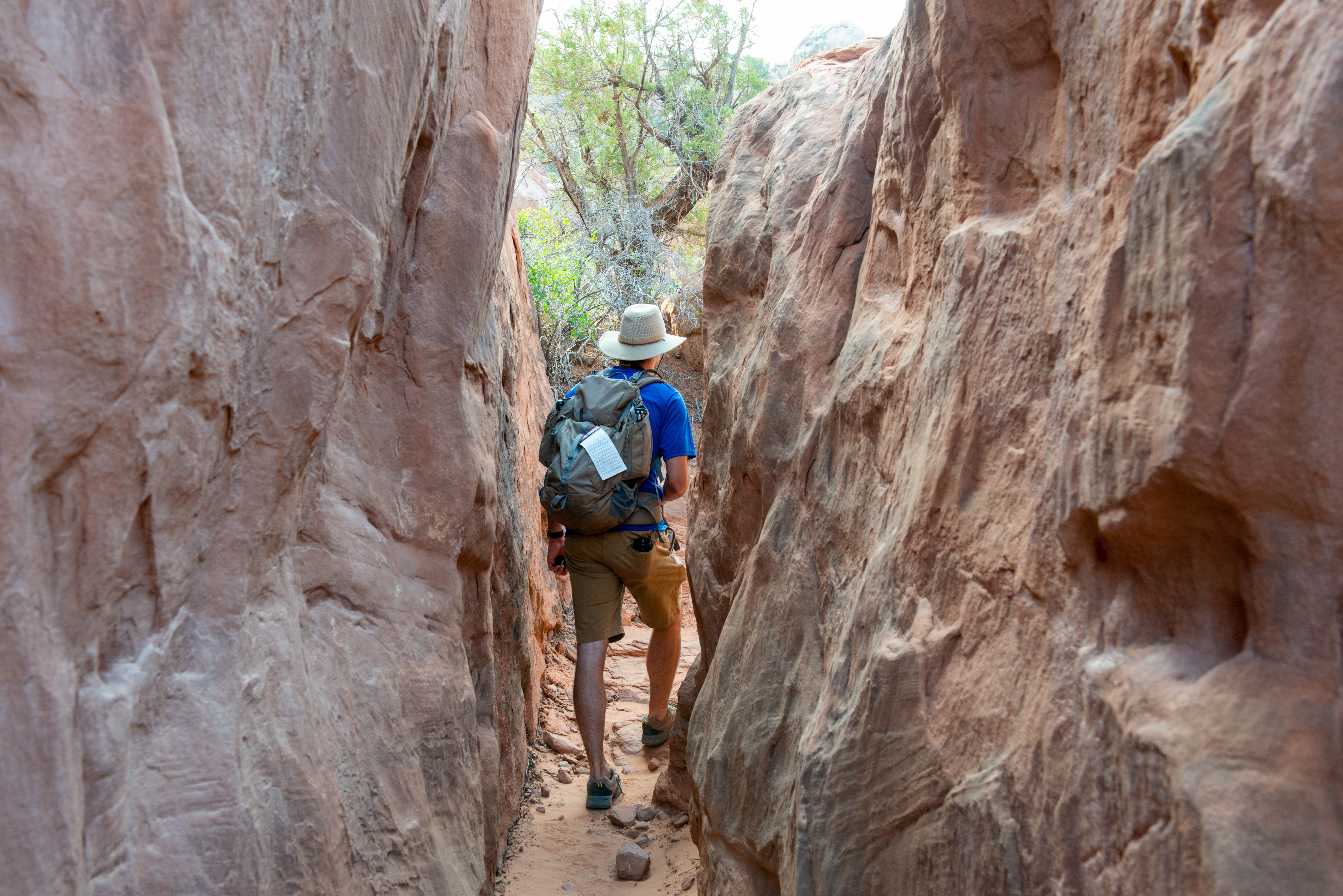
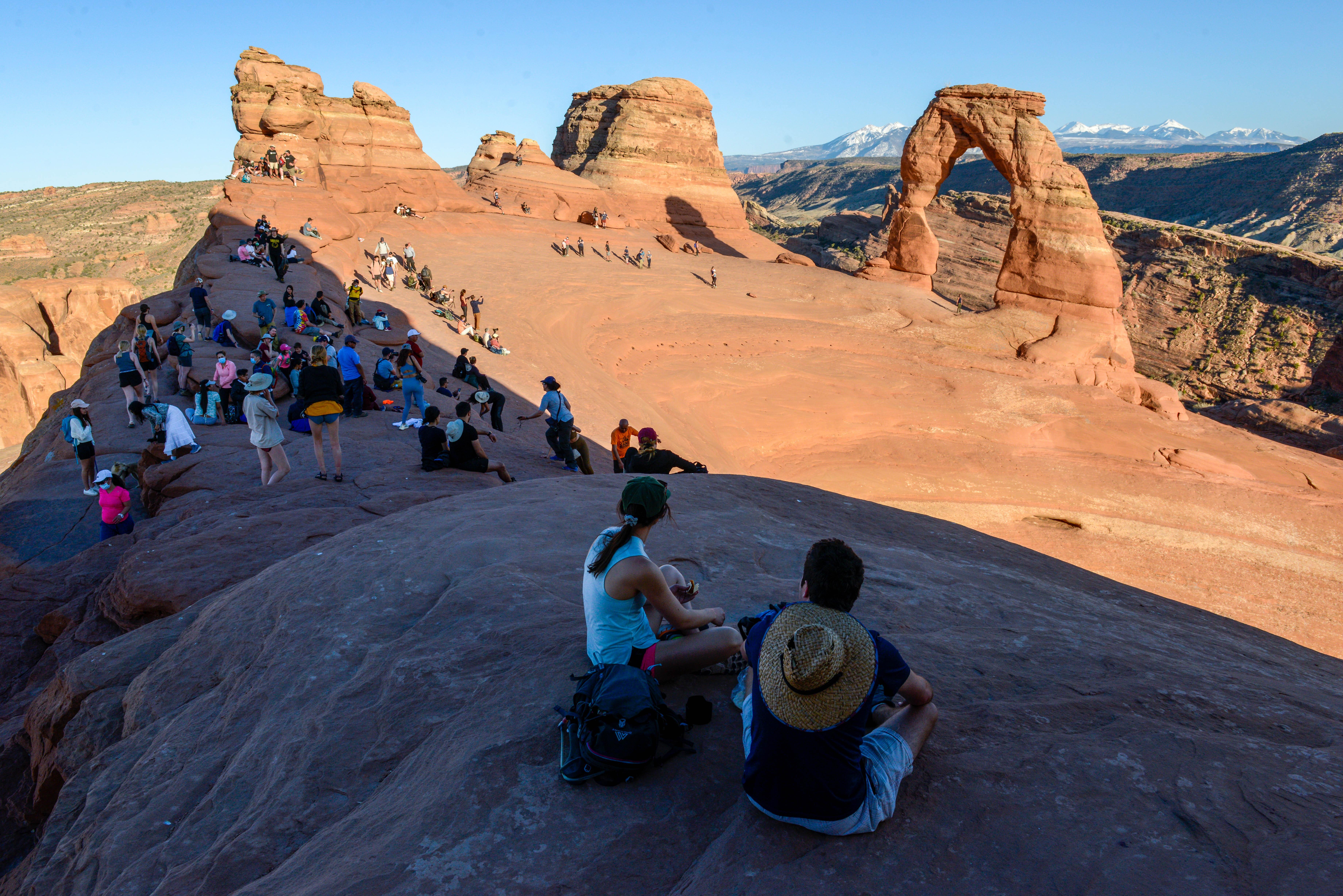
There are two ways to see the Fiery Furnace beyond the viewpoint and fence: Get a permit to explore on your own (year-round, ages 5 and older, fee, permit required) Join a ranger-led hike (spring through fall, ages 5 and older, fee, reservation required) A different kind of hiking Hiking in the Fiery Furnace is a different experience from other trails in the park. You encounter many dead ends and it can be easy to get lost. There are small markers for one counter-clockwise route in the Fiery Furnace, but there are many other possible paths, and getting lost is a real possibility. GPS units do not work well due to the towering sandstone walls. Navigating its complex passages requires physical agility and careful observation. To protect the wildlife and plants that inhabit sand dunes and drainages between the rock walls, you will need to choose your steps wisely. We recommend first-time visitors to the Fiery Furnace join a ranger-guided tour or get a permit with someone who has been before. Fiery Furnace Permits If you want to enter the Fiery Furnace on your own, you must obtain the permit in advance. You must reserve a Self-Guided Fiery Furnace Exploration Permit online from Recreation.gov or by calling 1-877-444-6777. See fee information below. Permits may be reserved up to seven days in advance and must be reserved at least two days prior to the trip date. Group size is limited to six people and children under age five are not allowed. Pets are prohibited. Fiery Furnace permits are valid for a specified date and for day-use only (sunrise to sunset). Reserved Fiery Furnace permits must be picked up at a designated time on the day before or day of your hike. All persons going on the permit must be present. The required orientation film will be played at the following times: 8, 8:30, 9, 9:30, and 10 am and 2, 2:30, 3, and 3:30 pm. Self-Guided Fiery Furnace Exploration Permits are for private use only; commercial groups are not permitted in the Fiery Furnace. You can find trails approved for commercial use in the guided interpretive day hike conditions document: Read more about commercial use. Permits sell out very quickly during the busy season. Go with a ranger Rangers offer Fiery Furnace hikes spring through fall. Tickets for these hikes are in high demand, and reservations are required. What should I expect? Everyone attending a Fiery Furnace hike should be aware of the challenging nature of the terrain and properly equipped for current conditions, including temperature extremes. During these physically demanding hikes, you will walk and climb on irregular and broken sandstone, along narrow ledges above drop-offs, and in loose sand. There are gaps you must jump across and narrow places that you must squeeze into and pull yourself up and through. In some places, you must hold yourself off the ground by pushing against the sandstone walls with your hands and feet. Due to the maze-like nature of the terrain, all participants must complete the hike once they enter the Fiery Furnace. To better judge the hikes' difficulty, you can watch a video or view a photo gallery. You must wear good hiking shoes or boots with gripping soles. No sandals or high heeled shoes are allowed. Each person must carry at least one quart or liter of water. You should stow water and other gear in a backpack so that your hands are free to help navigate the terrain. Tripods are not recommended. Age Restrictions Due to the terrain's difficulty, we do not allow children under the age of 5 on either hike. An adult must accompany all children aged 12 and under. What is the hike schedule? Hikes are only offered spring through fall, and schedules may change. Confirm availability on the park website or at the visitor center. How do I get a ticket? You can reserve tickets up to six months in advance at www.recreation.gov or by calling 877-444-6777 (in North America) or +1 518-885-3639 (international). Do I need to check in? Yes, if you have a reservation, you must check in—in person—at Arches Visitor Center at least one hour before the hike begins , or up to four days in advance. Be sure to allow plenty of time during the busy season to enter the park and to drive to the meeting location.

View
Two people walking up a steep paved trail through desert landscape.

Hike the Lower Cliff Dwelling Trail

Tonto National Monument

The Lower Cliff Dwelling Trail starts in the visitor center and winds up a steep path, ending in the Lower Cliff Dwelling. Along the trail are views of the cliff dwelling, various desert plants, and Roosevelt Lake. Exhibits along the trail provide more information about the people who lived here and about the general area. Benches are available on the way, but are fully exposed with little to no shade. This trail ends in the cliff dwelling where visitors can walk through portions of the structure and see expansive views of the basin below. The Lower Cliff Dwelling Trail is a moderate hike on a paved trail and is fully exposed with no shade. It is strongly recommended to bring water and to check the weather before visiting. Please check in at the visitor center before beginning your hike. This hike is available year-round, but hours do vary. See below for the most up-to-date hours and be aware that the trail may close due to excessive heat, lightning, bee activity, fire activity, or flooding. Trailhead: Visitor Center Parking: Available at visitor center. Distance: 1 mile (1.6 kilometers) roundtrip Elevation Gain: 350 feet (107 meters) Difficulty: Moderate (steep incline in a short distance) Services: Accessible restrooms and a water-fill station are available at the visitor center. Other Considerations Stairs: Stairs are throughout the dwelling and the cliff dwelling walls should not be used as support when stepping up. If you need support stepping up stairs, please bring hiking poles, a hiking stick, or use the hand or shoulder of a person that you are with. This is a cultural site. Within the cliff dwelling touching surfaces, leaning on walls, and entering closed areas is not permitted. Do your part to help preserve and protect the cliff dwelling so that future generations can enjoy visiting and learning at this site. Leave everything where you find it. Please leave all plants, flowers, rocks, and artifacts in place. Removal of anything is not permitted. Take only photos and leave only footprints. Delicate rocks and sensitive plants exist throughout this area. Please stay on the main trail and respect all posted signs.

View
2 people walk along a tree lined trail

Outdoor Pursuits and Trail Map

Carl Sandburg Home National Historic Site

"It is necessary now and then for a man to go away by himself and experience loneliness; to sit on a rock in the forest and to ask of himself, 'Who am I, and where have I been, and where am I going?'...If one is not careful, one allows diversions to take up one's time-the stuff of life" - Carl Sandburg as quoted from a letter to his friend, Ralph McGill. Enjoy the solitude of Connemara. Hike its many trails and take from it the energy to avoid diversions. The park offers 5 miles of hiking trails ranging from easy to moderately strenuous. Make sure to follow these tips before you plan your hiking adventure: Download a trail map . Young visitors can use TRACK Trail maps! Bringing a pet? Find information here . Check the weather. Dress for the conditions. Recreate Responsibly and follow Leave No Trace practices.

View
A rocky, mountain canyon sits across a calm lake.

Aspen Ridge - Boulder Ridge

Grand Teton National Park

Hikers looking for a longer trail to Phelps Lake will enjoy this moderate loop. Leaving from the Laurance S. Rockefeller Preserve, follow the Aspen Ridge Trail. The trail takes hikers through aspen groves and boulder fields before reaching Phelps Lake. Once at the lake, the forest opens up to reveal the lake and views into Death Canyon. Follow the Boulder Ridge Trail to complete the loop back.

View
A lake surrounded by trees as viewed from above.

Valley Trail - Phelps Lake Overlook

Grand Teton National Park

The Valley Trail is a strenuous, out and back trail that winds through alpine forests, connecting Teton Village to Grand Teton National Park's valley lakes. Start the trail from the Teton Village base area. After an initial ascent to the start of the Valley Trail via Jackson Hole Mountain Resort trails , follow the trail across rolling terrain before ascending to the Phelps Lake Overlook. Return the same way or continue on for a longer hike.

View
A rock pinnacle towers above at the top of a slope covered in boulders and green vegetation.

Granite Canyon

Grand Teton National Park

Rendezvous Mountain Trailhead Hike from the Teton Village base area to the top of Rendezvous Mountain via Jackson Hole Mountain Resort trails , or take the Aerial Tram ( fees apply ), to start this moderate hike down Granite Canyon. From the summit, the trail follows the ridgeline down to the South Fork of Granite Canyon with stunning views of the surrounding peaks. The trail takes visitors through dense forests and open fields that are bright with wildflowers during the growing season as they travel along Granite Creek down the canyon. Trails are not recommended for hiking until snow has melted, usually by late July. Take the Valley Trail and Jackson Hole Moutain Resort trails to return to the Teton Village base area. Valley Trail Access For a strenuous out and back hike, hike from the Teton Village base area via Jackson Hole Mountain Resort trails to the start of the Valley Trail. Take the Valley Trail to the Granite Canyon Trail and follow Granite Creek up the canyon through forests and wildflower meadows to the South Fork Granite Canyon trail junction. Return the same way. Granite Canyon Trailhead For a strenuous out and back hike, start from the Granite Canyon Trailhead and follow Granite Creek up the canyon through forests and wildflower meadows to the South Fork Granite Canyon trail junction. Return the same way.

View

Upcoming events

Upcoming programs and events at parks in this collection (from the NPS Events API).

Browse all events
Ranger Programs
Jun 24
Chesapeake & Ohio Canal National Historical Park

Cumberland Terminus Ranger Talk


Visitors are invited to join a short tour and talk at the Cumberland Terminus Visitor Center exploring the history of the Potomac River corridor as a vital transportation route through the Appalachian Mountains. The program highlights the active years of the C&O Canal while also examining the people, trade, and ideas that moved through the region before the canal was built and after its operations ended. Through stories of transportation, industry, and daily life, participants will gain a broader understanding of the canal’s role in shaping the region’s history.

10:00 AM - 10:30 AM
13 Canal Street Western Maryland Railway Station Cumberland, MD 21502
Guided Tours
Jun 24
Cumberland Island National Seashore

Plum Orchard Mansion Tour


Take a guided tour through a turn-of-the-century mansion home owned by members of the Carnegie Family on Cumberland Island.

11:00 AM - 11:45 AM
Plum Orchard Mansion is located 7 miles north of Sea Camp ferry dock.
Ranger Programs
Jun 24
Flight 93 National Memorial

Called to Action: The Flight 93 Story


This program is held beside the flagpole at the Memorial Plaza. Called to Action is a ranger program revisiting the Flight 93 story within the context of the September 11, 2001 terrorist attack. This 30-minute program is held where visitors can sit on benches and listen to a ranger talk about aspects of the terrorists' plan, personal stories of passengers and crew members, as well as the obstacles the passengers and crew members overcame to thwart Flight 93 from hitting the terrorists' planned target.

01:00 PM - 01:30 PM
The program and special use area at the Memorial Plaza is located outdoors adjacent to the Visitor Shelter. There are benches available for seating.
Special Events
Jun 24
Chesapeake & Ohio Canal National Historical Park

Great Falls Discovery Space: Sustainable Fishing


Stop by the Great Falls Tavern Visitor Center through the month of June to learn about sustainable fishing! For centuries people fished the Potomac River for food and sport. Today, many still use the canal as a favorite fishing spot. Through hands-on activities, you can learn more about the different species of fish that inhabit the Potomac River and the canal, understand safe fishing practices, and discovery the ecosystems that rely on fish.

09:00 AM - 04:00 PM
Great Falls Tavern 11710 MacArthur Blvd. Potomac, MD 20854
Ranger Programs
Jun 26
Flight 93 National Memorial

Called to Action: The Flight 93 Story


This program is held beside the flagpole at the Memorial Plaza. Called to Action is a ranger program revisiting the Flight 93 story within the context of the September 11, 2001 terrorist attack. This 30-minute program is held where visitors can sit on benches and listen to a ranger talk about aspects of the terrorists' plan, personal stories of passengers and crew members, as well as the obstacles the passengers and crew members overcame to thwart Flight 93 from hitting the terrorists' planned target.

11:00 AM - 11:30 AM
The program and special use area at the Memorial Plaza is located outdoors adjacent to the Visitor Shelter. There are benches available for seating.
Guided Tours
Jun 27
Chesapeake & Ohio Canal National Historical Park

Guided Tours of Rileys Lockhouse


Explore the life of a lockkeeper and family in the 1870's time period with a guided tour of one of the C&O Canal's original lockhouses. Girl Scouts offer free tours of the lockhouse and grounds at Lock 24. In addition, there may be various Victorian Era demonstrations such as laundry, cider pressing, making lemonade, churning butter or ice cream and more. Visitors are welcome to participate in the activities and taste the results. Open every Saturday and Sunday 1pm-4pm, March 21 st through July 12 th and August 16 th through December 12 th . The lockhouse will be closed for bad weather.

01:00 PM - 04:00 PM
Rileys Lockhouse Rileys Lock Rd Poolesville, MD 20837
Ranger Programs
Jun 27
Flight 93 National Memorial

Called to Action: The Flight 93 Story


This program is held beside the flagpole at the Memorial Plaza. Called to Action is a ranger program revisiting the Flight 93 story within the context of the September 11, 2001 terrorist attack. This 30-minute program is held where visitors can sit on benches and listen to a ranger talk about aspects of the terrorists' plan, personal stories of passengers and crew members, as well as the obstacles the passengers and crew members overcame to thwart Flight 93 from hitting the terrorists' planned target.

01:00 PM - 01:30 PM
The program and special use area at the Memorial Plaza is located outdoors adjacent to the Visitor Shelter. There are benches available for seating.
Workshops
Jun 27
Boston Harbor Islands National Recreation Area

Art in the Park on Georges Island


Unleash your creativity with a variety of art activities designed to enrich your island experience. Test your hand at watercolors, write and illustrate nature haikus, learn to decode signal flags, and explore sun printing. NOTE: Ferry tickets must be purchased to attend this event. Georges Island is accessible via public ferry. To purchase ferry tickets, please visit the Ferry Information page on the Boston Harbor Islands partnership website . Events may be effected by weather. Please ask the Boston Harbor Welcome Center for updates.

11:30 AM - 03:00 PM
Georges Island
Ranger Programs
Jun 28
Flight 93 National Memorial

Called to Action: The Flight 93 Story


This program is held beside the flagpole at the Memorial Plaza. Called to Action is a ranger program revisiting the Flight 93 story within the context of the September 11, 2001 terrorist attack. This 30-minute program is held where visitors can sit on benches and listen to a ranger talk about aspects of the terrorists' plan, personal stories of passengers and crew members, as well as the obstacles the passengers and crew members overcame to thwart Flight 93 from hitting the terrorists' planned target.

01:00 PM - 01:30 PM
The program and special use area at the Memorial Plaza is located outdoors adjacent to the Visitor Shelter. There are benches available for seating.
Ranger Programs
Jun 29
Flight 93 National Memorial

Called to Action: The Flight 93 Story


This program is held beside the flagpole at the Memorial Plaza. Called to Action is a ranger program revisiting the Flight 93 story within the context of the September 11, 2001 terrorist attack. This 30-minute program is held where visitors can sit on benches and listen to a ranger talk about aspects of the terrorists' plan, personal stories of passengers and crew members, as well as the obstacles the passengers and crew members overcame to thwart Flight 93 from hitting the terrorists' planned target.

01:00 PM - 01:30 PM
The program and special use area at the Memorial Plaza is located outdoors adjacent to the Visitor Shelter. There are benches available for seating.
Workshops
Jul 4
Chesapeake & Ohio Canal National Historical Park

Music on the Canal at Great Falls


Join us for our Music on the Canal program! Musicians from the Northern Virginia Dulcimer Group will they share their interpretations of 19th century music and perform songs on a variety of historical instruments, including dulcimers, banjo, and upright bass. Stop in to listen and learn about music of the canal era during your visit! Event may take place outside or indoors depending on the weather.

10:00 AM - 12:00 PM
Great Falls Tavern 11710 MacArthur Blvd. Potomac, MD 2085
Guided Tours
Jul 5
Chesapeake & Ohio Canal National Historical Park

Abner Cloud House Tour


Built in 1801 by Abner Cloud, Jr., the house is considered one of the finest examples of Federal architecture in Washington D.C. Pre-dating the construction of the C&O Canal, the home of Abner Cloud served as the center of the family farm and fishing business. Tour the Abner Cloud House and learn more about early 19th century farming, architecture, and the people who lived and worked on the property. The three-story, stone home is operated in parntership with The Colonial Dames of America and is open for tours on the first Sunday of each month from 12:00 pm - 5:00 pm. The Abner Cloud House is located at Fletchers Cove . Admission to Fletchers Cove and the Abner Cloud House is free.

12:00 PM - 04:00 PM
4940 Canal Rd NW, Washington, DC 20007

All parks (275)

Acadia National Park
National Park

Acadia National Park

ME

Acadia National Park protects the natural beauty of the highest rocky headlands along the Atlantic coastline of the United States, an abundance of habitats, and a rich cultural heritage. At 4 million visits a year, it's one of the top 10 most-visited national parks in the United States. Visitors enjoy 27 miles of historic motor roads, 158 miles of hiking trails, and 45 miles of carriage roads.

Agate Fossil Beds National Monument
National Monument

Agate Fossil Beds National Monument

NE

In the early 1900s, paleontologists unearthed the Age of Mammals when they found full skeletons of extinct Miocene mammals in the hills of Nebraska -- species previously only known through fragments. At the same time, an age of friendship began between rancher James Cook and Chief Red Cloud of the Lakota. These two unprecedented events are preserved and protected here... at Agate Fossil Beds.

Ala Kahakai National Historic Trail
National Historic Trail

Ala Kahakai National Historic Trail

HI

Established in 2000 to preserve, protect and interpret traditional Native Hawaiian culture and natural resources, Ala Kahakai National Historic Trail is a 175-mile corridor encompassing a network of culturally and historically significant trails. This "trail by the sea" traverses wahi pana (storied landscapes), ancient Hawaiian sites and over 200 ahupuaʻa (traditional land divisions).

Allegheny Portage Railroad National Historic Site
National Historic Site

Allegheny Portage Railroad National Historic Site

PA

The first railroad to cross the Allegheny Mountains, the Allegheny Portage Railroad was the final piece of the Pennsylvania Main Line Canal. "The Portage" opened in 1834, marking the first time that there was one, direct route between Philadelphia and Pittsburgh. All things to all people, it served merchants, passengers, slaves in pursuit of freedom, and soldiers from the Mexican War.

Amistad National Recreation Area
National Recreation Area

Amistad National Recreation Area

TX

An oasis in the desert, Amistad National Recreation Area consists of the US portion of the International Amistad Reservoir. Amistad, a Spanish word meaning "friendship," is known for excellent water-based recreation, camping, hiking, and rich cultural history dating back nearly 5,000 years. Amistad is also home to a wide variety of plant and animal life both above and below the water.

Aniakchak National Monument & Preserve
National Monument & Preserve

Aniakchak National Monument & Preserve

AK

Given its remote location and challenging weather conditions, Aniakchak is one of the most wild and least visited places in the National Park System. This landscape is a vibrant reminder of Alaska's location in the volcanically active "Ring of Fire," as it is home to an impressive six mile (10 km) wide, 2,500 ft (762 m) deep caldera formed during a massive volcanic eruption 3,500 years ago.

Antietam National Battlefield
National Battlefield

Antietam National Battlefield

MD

23,000 soldiers were killed, wounded or missing after twelve hours of savage combat on September 17, 1862. The Battle of Antietam ended the Confederate Army of Northern Virginia's first invasion into the North and led Abraham Lincoln to issue the preliminary Emancipation Proclamation.

Apostle Islands National Lakeshore
National Lakeshore

Apostle Islands National Lakeshore

WI

Apostle Islands National Lakeshore, located at the northern tip of Wisconsin's Bayfield Peninsula, features 21 stunning islands, a scenic 12-mile shoreline along Lake Superior, and is located within the ancestral homeland of the Ojibwe people. Established in 1970, the park showcases picturesque sea caves, sandy beaches, and the largest collection of lighthouses in the National Park system.

Appalachian National Scenic Trail
National Scenic Trail

Appalachian National Scenic Trail

CT,GA,MA,MD,ME,NC,NH,NJ,NY,PA,TN,VA,VT,WV

The Appalachian Trail is a 2,190+ mile long public footpath that traverses the scenic, wooded, pastoral, wild, and culturally resonant lands of the Appalachian Mountains. Conceived in 1921, built by private citizens, and completed in 1937, today the trail is managed by the National Park Service, US Forest Service, Appalachian Trail Conservancy, numerous state agencies and thousands of volunteers.

Appomattox Court House National Historical Park
National Historical Park

Appomattox Court House National Historical Park

VA

On April 9, 1865, the surrender of the Army of Northern Virginia in the McLean House in the village of Appomattox Court House, Virginia signaled the effective end of the nation's largest war. Questions remained: could the nation reunite as one? How would emancipation be realized?

Arches National Park
National Park

Arches National Park

UT

Discover a landscape of contrasting colors, land forms, and textures unlike any other. The park has over 2,000 natural stone arches, hundreds of soaring pinnacles, massive rock fins, and giant balanced rocks. This red-rock wonderland will amaze you with its formations, refresh you with its trails, and inspire you with its sunsets.

Arkansas Post National Memorial
National Memorial

Arkansas Post National Memorial

AR

Located at the confluence of two rivers, Arkansas Post has served as a gathering place for many cultures throughout human history - it represents cultural cooperation, conflict, synthesis, and diversity.

Showing 112 of 275 parks